The role of GIS as Smart Tool for
Intelligent Communities
Angela Ionita1, Marcel Foca2, Claudiu Zoicas3, Marius
Ienculescu-Popovici2
1Research
Institute for Artificial Intelligence, Romanian Academy,
2 Intergraph
Computer Services, Romania,
3 Emergency Situations
Inspectorate -Inspectoratul pentru Situatii de Urgenta – Bihor County, Romania
Abstract
GIS
is important in business because most business problems include significant
spatial components and GIS enables decision makers to leverage their spatial
data resources more effectively. While most organizations have an intense
desire to know their customers, they often possess an incomplete paradigm of
the actual data that describe their customers. The process of defining and
extending organizational knowledge about customers - which includes providing
necessary process improvements and tools to actually sense, describe, and
respond to customers - can be significantly enabled by geographic technologies.
GIS is useful for managing databases, even extremely large applications such as
data warehouses, because it provides an enhanced data structure that is based
on the natural organization that geography provides. In other words, data can
be organized in a spatial order; the very same organizational order that is
used by most managers when they think about their operations and markets.
Today, GIS-based data sources vary from satellite imagery used to validate the
number of new houses in a retailmarketretail market to
the individual people-point data of the consumers living in those houses. Data
such as these can add significant value to an organization's database by
helping to validate and extend their own proprietary resources. Structured in 5
sections this paper, the
objective of this paper was to make a synthesis of the dedicated literature
identifying the trends and developments in Smart Tools for Intelligent
Communities (STIC) – some time called reporting tools, some time DSSs and
some time GISs - by surveying the past, present and to try to discovery the future,
giving some examples from Romanian experience.
1. Introduction
"The problem
we're really up against is that we're moving into a knowledge economy, yet most
companies and nearly all individuals are ill-prepared for working in that
economy," says
Jonathan
Spira, chief analyst at Basex and author of Managing the Knowledge Workforce
(Mercury Business Press, 2005).
GIS
is important in business because most business problems include significant
spatial components and GIS enables decision makers to leverage their spatial
data resources more effectively. While most organizations have an intense
desire to know their customers, they often possess an incomplete paradigm of
the actual data that describe their customers. The process of defining and
extending organizational knowledge about customers - which includes providing
necessary process improvements and tools to actually sense, describe, and
respond to customers - can be significantly enabled by geographic technologies.
GIS is useful for managing databases, even extremely large applications such as
data warehouses, because it provides an enhanced data structure that is based
on the natural organization that geography provides. In other words, data can
be organized in a spatial order; the very same organizational order that is
used by most managers when they think about their operations and markets.
Today, GIS-based data sources vary from satellite imagery used to validate the
number of new houses in a retailmarketretail market to
the individual people-point data of the consumers living in those houses. Data
such as these can add significant value to an organization's database by
helping to validate and extend their own proprietary resources.
Business
intelligence promises all users accessing all data, with all capabilities,
understanding what happened, why, and determining what action should they take
to help the organization succeed. (The Full Promise of Business Intelligence by Cognos
Corporation)
In other words, Business
Intelligence (BI)
encompasses the gathering, storing, analyzing and accessing of data. It
includes such applications as decision support systems, statistical analysis,
forecasting, querying and report generation, and online analytical processing,
commonly known by its acronym, OLAP. By transforming musty mountains of raw
data into accurate, relevant and useful information, BI results in better
decision-making.
“Questions
that used to take weeks of research to answer with only 80 percent accuracy can
now be answered within minutes,” said Dr. Norman Reid[1].
“But from a government’s standpoint, the benefits of BI go beyond enhanced
efficiency to a way of evaluating program effectiveness that we never had
before – in effect improving government’s accountability to the public.”
Each of the
functions of
BI and GIS suggest four areas in which research should focus: human factors, GIS data management, decision making and
collaboration, and planning systems.
2. GIS and[a1] Bussiness
Intelligence
The term of Business
Intelligence was used as early as September, 1996, when a Gartner Group report
said:
“By 2000, Information
Democracy will emerge in forward-thinking enterprises, with Business
Intelligence information and applications available broadly to employees,
consultants, customers, suppliers, and the public. The key to thriving in a
competitive marketplace is staying ahead of the competition. Making sound
business decisions based on accurate and current information takes more than
intuition. Data analysis, reporting, and query tools can help business users
wade through a sea of data to synthesize valuable information from it - today
these tools collectively fall into a category called "Business
Intelligence."
It
is important to mention that Business Intelligence (BI) is not a single
application. It consists of a series of components that interact behind the
scenes to extract electronic data, assemble it, analyze it and display it in a
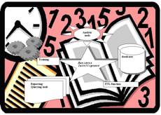
form that is easy to work with and understand. These components include (Figure
1):
|
|
|

3c.
Analytic tools – Analytic tools summarize data and compare
it to still more data to convert it into usable information. This includes the
creation of “What if?” scenarios and modeling of results.
4d.
Reporting/Querying tools – These tools
consist of a variety of reporting tools that create reports, graphs and charts.
These tools help knowledge workers understand and use information in ways they
might never have considered before BI tools became available and simple to use.
5e.
Training – To make the most of a new BI deployment,
companies should always consider comprehensive training programs for their
employees. Once the goals are established, a company should determine the best
means of for providing
the required business process views from the data it already collects. Company
officials should then analyze that data source’s characteristics and the type
of errors it contains in order to successfully integrate the data with
information from other sources.
Because
BI is a powerful, inexpensive way to easily analyze years of data, Nadia De
Luca[2]
from Microsoft warns agencies not to try to do too much at once. Organizations
should take an incremental approach by identifying immediate requirements or
issues that might be causing problems for a company. For example, a company
might determine it needs timely financial data. This is a great place to begin.
Once a specific problem is solved, or a functional area is included in the BI
project, managers should target more complex business issues and leverage the
experience and skills gained from the first project.
“Technologically,
there is nothing that will hinder you from being successful,” said Nadia De Luca1. “Once
the decision is made to deploy a Business Intelligence solution, it’s just a
few short months before an agency can begin realizing swift and accurate
decision- making that BI makes possible.”
23. Business
Intelligence vsvs. Geographic
Information System
23.1. What is Business Intelligence?
The term of Business
Intelligence was used as early as September, 1996, when a Gartner Group report
said:
“By 2000, Information
Democracy will emerge in forward-thinking enterprises, with Business
Intelligence information and applications available broadly to employees,
consultants, customers, suppliers, and the public. The key to thriving in a
competitive marketplace is staying ahead of the competition. Making sound
business decisions based on accurate and current information takes more than
intuition. Data analysis, reporting, and query tools can help business users
wade through a sea of data to synthesize valuable information from it - today
these tools collectively fall into a category called "Business
Intelligence."
It
is important to mention that Business Intelligence (BI)
is not a single application. It consists of a series of components that
interact behind the scenes to extract electronic data, assemble it, analyze it
and display it in a form that is easy to work with and understand. These
components include (Figure 1):
|
Figure 1: The components of Business Intelligence |
a.
A database – Modern BI software can make use of
information stored in most any database in its current form,
avoiding an expensive “rip and replace” scenario where old, albeit reliable
technology is supplanted by new products. b.
An ETL (Extract, Transform
and Load data) function –
BI applications extract data from databases or transaction systems, check it
for errors, clean it up, translate it into a uniform format and use it to
populate a new database. |
c.
Analytic tools – Analytic tools summarize data and compare
it to still more data to convert it into usable information. This includes the
creation of “What if?” scenarios and modeling of results.
d.
Reporting/Querying tools – These tools
consist of a variety of reporting tools that create reports, graphs and charts.
These tools help knowledge workers understand and use information in ways they
might never have considered before BI tools became available and simple to use.
e.
Training – To make the most of a new BI deployment,
companies should always consider comprehensive training programs for their
employees. Once the goals are established, a company should determine the best
means for providing the required business process views from the data it
already collects. Company officials should then analyze that data source’s
characteristics and the type of errors it contains in order to successfully
integrate the data with information from other sources.
Because
BI is a powerful, inexpensive way to easily analyze years of data, Nadia De
Luca[3]
from Microsoft warns agencies not to try to do too much at once. Organizations
should take an incremental approach by identifying immediate requirements or
issues that might be causing problems for a company. For example, a company
might determine it needs timely financial data. This is a great place to begin.
Once a specific problem is solved, or a functional area is included in the BI
project, managers should target more complex business issues and leverage the
experience and skills gained from the first project.
“Technologically,
there is nothing that will hinder you from being successful,”
said Nadia De Luca1. “Once the decision is made to deploy a
Business Intelligence solution, it’s just a few short months before an agency
can begin realizing swift and accurate decision- making that BI makes possible.”
Business Intelligence (BI) is a process
for increasing the competitive
advantagecompetitive advantage of a business by
intelligent use of available data in decision makingdecision making.
The five key stages of Business Intelligence are:
|
Data Sourcing |
BI is about extracting information from
multiple |
|
Data Analysis |
BI is about synthesizing useful
knowledge from collections of data. It is about estimating current trends,
integrating and |
|
Situation Awareness |
BI is about filtering out the
irrelevant information, and setting the remaining information in the context of the
business and its |
|
Risk Assessment |
BI is about discovering what
plausible actions might be taken, or decisions made, at different times. It is
about helping the companies weigh up the current and future risk, cost or
benefit of taking one action over another, or making one decision versus
another. It is about inferring and |
|
Decision Support |
BI is about using information
wisely. It aims to provide
warning the company of important events, such as takeovers, market changes,
and poor staff performance, so that it can take preventative steps. It presents
the information
needed by companies, when they need it. |
23.2. What is Geographic Information System ?System?
A
Geographic Information System (GIS) is a tool for linking attribute databases
with digital maps. But GIS is really much more than this simple definition would
imply. In fact, several definitions of GIS have been proposed, each of which
suggest that GIS is much more than merely an electronic mapping tool (Brian E.
Mennecke, 1997). Something that is common to most of these definitions is the
notion that GIS not only provide users with an array of tools for managing and
linking attribute and spatial data, but they also provide users with advanced
modeling functions, tools for design and planning, and advanced imaging
capabilities. While many of these capabilities also exist in other types of
systems, such as visualization and virtual reality systems, GIS are unique
because of their emphasis on providing users with a representation of objects
in a cartographically-accurate spatial system and on supporting analysis and
decision making. Although data capture, manipulation, and management are
important functions of GIS, most GIS are eventually used to support data
analysis and decision making. The literature in the management information
systems field is rich with descriptions of various decision support
technologies that can be applied to GIS. If it can try to move in a practical
framework, a Decision Support System (DSS) includes various subsystems
including data management, model management, knowledge management subsystem,
and dialog management subsystems. A GIS includes similar subsystems, albeit
subsystems which are spatially enabled. Similarly, a GIS must have a model
manager that includes the typical functions, models, and statistical operations
present in a DSS, but it also must provide the user with spatial models and
capabilities that can be used to perform spatial modeling and spatial
statistical calculations. To help the user manage the complexity involved in
integrating these models with attribute and spatial data, several developers
have incorporated knowledge management facilities within GIS (see
Leung and Leung 1993a, 1993b; Skidmore at. al. 1991; Smith and Yiang 1991; Wu et
al. 1988).
Finally, a GIS has a dialog management subsystem that enables users to query
and output attribute data, but it also includes spatial query and output
capabilities. For example, a typical aspatial DSS will include a data
management subsystem designed to manage textual or, in some cases,
object-oriented data. A GIS must not only be able to manage these types of
data, but also manage and integrate spatial data (e.g., data which include
cartographic coordinates). Using such a framework it becomes clear that GIS
include all of the features that are in a DSS; however, they also include
several other components [4].
On
the short, the four GIS functions are:
Spatial
imaging refers to the
fundamental GIS capability of representing displays of data and information
within a spatially - defined coordinate system.
The database management function represents
the capability of GIS to store, manipulate, and provide access to (numerical
and alphanumerical) data.
The decision modeling function represents
the capability of GIS to be used to provide support for analysis and decision
making.
The design and planning
function represents
the capability of GIS to be used to create, design, and plan.
34. Implementation in
Romania
In Romania, in our
opinion, the government and local authorities has a role in cataloguing and
tracking evolving research
topics of all kinds and supporting those that best serve the nation and the
world community. By participating as technology users in industry consortia
(such as Open GeoSpatial Consortium in USA) that include users in technology
planning and specification
efforts, central and local public administration organisms can:
· Ensure that the
technology provider community meets agency needs and
·
Influence the
direction of technology that will become part of the larger economy and
culture.
In connection with National
Geographical
Information
Infrastructure
(NGII) strategy for
development, in Romania, as probably in most of developing countries, it was a
balance between the top-down and bottom-up approaches. The top-down
approach is required to specify strategic goal and vision, prioritize plans,
arrange core funding, contribute to the definition of fundamental datasets,
building a clearinghouse, develop metadata standards, and to resolve
information policy issues. The bottom-up approach aims at promoting various
local initiatives and building application-specific and enterprise-wide
geospatial databases. This should be seen as an evolutionary approach to
accessing, combining and using data though user-centric methodologies such as
prototyping, and cultivation of standards.
And sometime, some
trends influenced the current development in NGII strategy in Romania. One of
this could be formulated as follows: Information
Infrastructure (II)/Spatial Data Infrastructure
(SDI) researchers in the USA and
elsewhere in the developed world now discard notions of “government as a
builder of infrastructure” and embrace instead those of “government as a
rule-setter” or “enabler”, especially in the extremely competitive information
industry sector (LeGates, 1995; Craglia & Masser, 2003).
Another
is the focusing on “I” from SDI but it is necessary to argue that understanding
the dynamics of infrastructure evolution in a specific nation can help to
identify some locally
relevant mechanisms
and strategies that can contribute to close some of the gaps.
34.1. Smart Tools for Intelligent Community (STIC)
Based on this trends
and on the syntagm of Smart
Tools for Intelligent Community[5]
the mainly goal of the developing is to build of a framework for the
construction of systems that play an active role in supporting both knowledge
processing and task performance. In our point of view, such systems targeted
intelligent decision support without relying, necessarily, on Artificial
Intelligence techniques and technology.
The approach adopted in this work differs from
traditional approaches in decision support systems (DSS) in that it is not
focusing merely on managerial decision-making but attempts to reflect
organizational realities. In adopting an organizational perspective, we see
knowledge processing as an integral part of work practices in a modern
organization and not the exclusive prerogative of managerial work. This
position entails that workers are engaged in both knowledge processing and task
performance, in contrast to traditional managerial work that focuses only on
the former. This is consistent with the multiple hypostases of citizens in
Intelligent Community: from decision makers to every citizen. As a consequence,
the proposed framework intends to integrate and support both task performance
and knowledge processing.
In “Spatial
Decision Support Systems – An approach for Intelligent Communities”
(Ionita, A., Visan, M., Foca, M., 2003a; 2003b)
based on architectural approach from (Henry Linger and
Frada Burstein)our
paper “Intelligent Decision
Support in the Context of the Modern Organization” by Henry Linger and
Frada Burstein, which is considerate as fundamental for us,
in “Spatial Decision Support Systems – An
approach for Intelligent Communities” (Ionita, A., Visan, M., Foca, M., 2003ab) is
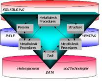
proposed a multi-layered architecture for Smart Tools, as shown in Figure 2,
composed of three layers representing the organization of work.
Figure 2 also indicates the interaction between the
layers occurs through the influence of the structuring layer on the task. The interaction between
layers is bi-directional as the rules/procedures could automatically evolve as
a result of performing the task. Alternatively, the data generated by the task
can be used when reflecting on or evaluating the task. In additional, according
to our experience (Ionita, A., Ilie, R. 2000a; Ionita, A., C. Pribeanu, C.
Barbălată 2001; Ionita, A., 2002a) it is very important to take into account the local culture and education of the
citizens based on the heterogeneous technologies and the technology itself:
from communications to GIS technology. It is not a mistake to consider as
resource the technology because in our experience we discovered a lot of
extensions of different technology packages in house developed for the
interests of the community and based on the particularly requests of the unique
player. Also we introduced this layer because of the mainly “actors” (mentioned
in Ionita, A., 2000b; Ionita, A., 2000c,) from the market in an Intelligent
Community, including the roles and the rules imposed by the laws and by the
(un)written laws of the market at this level. There
are cultures within cultures in large organizations. Every department has its
own unspoken and unwritten rules. One-size implementation will not fit all.
Every discrete community in the bottom-up approach is required to
"translate" the top-down message and develop its own diversity and
inclusion strategies that are consistent with the spirit and intent of the
corporation. Developing the potential of every individual to be a better
community citizen is the goal.
In the development of Smart Tool for Risk Evaluation and Management of
Disasters (STREMD)
presented in (Ionita, A., Visan, M., Foca, M, 2003a) it ishas
been necessary to stress on the following aspects:
·
The smart
tools have the availability to mix the data from earth observations, GPS and
sensors and GI with advanced methods and technologies for information’s
capturing from environmental data. That is the effectively contribution to the
decision making for risk assessment, specific actions including telemedicine
urgency (; fFor example the UN Global Disaster Alert and
Coordination System (GDACS) provide automatic e-mail or SMS alert regarding
earthquakes, containing relevant data
such as estimated afflicted population or risk of TSUNAMI (http://www.gdacs.org/). This
information can be integrated in the STREMD and lead to fast and accurate
decision regarding the request for adequate foreign assistance. Another relevant
example, is the use of Fire Information for Resource Management System – FIRMS, (NASA, University
of Maryland and FAO) that provide e-mail alerts regarding the fires observed on
a specific defined area . http://dev.geog.umd.edu/alerts/alerts.phtml)
·
It is
necessary a deeply analyze and comparison of performance, scalability and
efficiency of the existing tools, methods and systems for risk evaluation in
order to answer to new challenges of new society;
·
It will be
necessary the activities for pre-standardization leading to the data models
harmonized, metadata, functional architectures and concrete approaches of
services offered to the citizens in different hypostases: from decision makers
to every citizen.
The development was done based on:
·
The studies
and research in the area of interactivity and user-friendliness of the
geographical interfaces for portable devices and internet, multiple scale GI
management, time representation in GIS, the contractual models for exploring
and exploitation of geospatial information;
·
The survey of
user’s requests in the relevant scenario applications;
·
The
development of the component’s system and the integration in a demonstrative
Pilot Project supported by local authorities;
·
The testing
of Pilot based on real world scenarios in the risk/crisis management at the
different levels: local/national/regional.
|
Figure 2. The Architecture for Smart Tool (adopted and adapted from Henry
Linger and Frada Burstein, Intelligent
Decision Support in the Context of the Modern Organisation) |
Figure 3. Geospatial Data Base as support for
substantiation of the plans concerning risk management at the
local/national/regional levels with different sectors of activities in an
Intelligent Community (Emergency Situations |
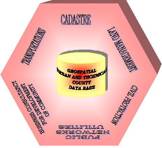
The project
presented here come from the family of Turnkey projects developed by Intergraph
Computer Services s.r.l in Romania, for the County Inspectorates for Civil ProtectionEmergency Situations
in order to provide the organization of specific information in a global
concept called Geospatial (Urban or County Technical) Data
Base (Figure 2) as support for substantiation of the
plans concerning risk management at the local/national/regional levels. In ANNEX 1ANNEX
1 we presented some aspects and specialized
reports.
The kernel of technical solution adopted for this
project is the better commercial GIS platform available now, satisfying all
requests formulated by users: from the County Inspectorates for Emergency
Situations Civil Protection to the different
companies from public and private sector and every citizen, according to the
current laws. This solution provide the possibility of automatic taking over of
existing data offering in the same time, real correlated information as support
for decision making process for the coordinators of the technical sub
commissions, mayors, commanders, prefects etc and for every citizen.
|
Figure 4. The architecture
based on Smart Tools for
Intelligent Community
(at local level) |
This solution ensures the background for the
building of nationwide solution based on ICT and covering all activities at
the local, regional, central levels in collaboration with the information
providers and other players (Figure 4). |
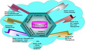
This
solution ensures the background for the building of nationwide solution based
on ICT and covering all activities at the local, regional, central levels in
collaboration with the information providers and other players (Figure 4).
34.2. Other
Smart Tools for Intelligent Community
Based on the same framework presented here and the
same global concept and because of the limit of space and time, we would like
to enumerate other Success Stories which can complete the picture of Smart
Tools for Intelligent Community:
- · Smart Tool for Urban Planning
- ·
Smart Tool
for cadaster and land management
- ·
 Smart
Tool for Road Management
Smart
Tool for Road Management - ·
Smart Tool
for Managing and monitoring the water distribution network
- ·
Romanian Mining
Book - Mining Cadastre Control and Mining Titles Registry
for County Council of Constanţa -
Negru Vodă City based on Intergraph techologytechnology
implemented for City Hall of
Bucharest based on Intergraph GIS Solution containing also the application
for importing and
managing data from ASCII files generated by different GIS systems
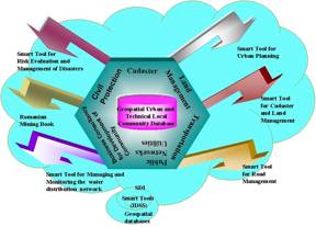
Figure 4. The
arhitecture based on Smart Tools for
Intelligent
Community (at local level)
implemented at Council of Ilfov
County and Council of Gorj County, the solution, based on Intergraph GeoMedia
technology, is dedicated to plannings, designing, constructing and
maintaining the district’s roads.
implemented for
Apaterm Oradea
– water and heating distribution company in city of Oradea. The
solution – based on Intergraph technology - include tools for
managing and monitoring the water distribution network for City of Oradea
and fallow the actual workflow from company.
implemented
at National Agency Mineral Resources based on Intergraph GeoMedia
customization and integration with existing mineral databases.
· Smart Tool for Urban
Environmental Impact Assessment in relation with Urban Planned Land-Use,
using Open-GIS technology and pollution levels estimation procedures
Implementation
for “A pilot system for Urban Environmental Impact Assessment in
relation with Urban Planned Land-Use, using Open-GIS technology and
pollution levels estimation procedures - ASSURE (ASsessment System for URban Environment)”, European Project: ENV
99/RO/006746 http://life-assure.inmh.ro
The partners:
National Institute of Meteorology and Hydrology (NIMH), City Hall of Baia
Mare, Inspectorate for Environmental Protection Baia Mare, Meteo-France
·
Smart
Tool for special integration of technical information, both geospatial and
alphanumerical, but also the integration of the processes
Implemented for
Transelectrica, for the 101 users from 8 divisions, by a Phare 2000
investment, contracted by the Ministry of Public Finances and implemented
by the Ministry of the Economy and Commerce.
·
Smart
Tool for Monitoring and Management of the
Emergency Situations
One prototype
has been developed step by step with the support of Oradea GIS Consortium
(http://www.marketwatch.ro/articles.php?ai=973&filter=-1&st=0Bas,
I, Zoicas, C, 2005).
The Inspectorate for Emergency
Situations Inspectorate of Bihor Ccounty havehas
participated to VIREX 01 RO-HU, a virtual cross border
emergency situation management exercise. The VIREX
have been organized in the frame of the INTERREG III C AWARE project, and
have used a smart tool developed during the project. (http://www.isubihor.rdsor.ro/iv1.htm)
Another relevant
experience has been developed at the level of Gorj Ccounty
(http://www.marketwatch.ro/articles.php?ai=974&st=0&filter=-1).
Another Smart
Tools for Intelligent Community based on the Intergraph solutions was presented
in Annual Conferences of Intergraph’s Users Solution from 2003 to 2006,
in Romania.
5. Conclusions
The objective
of this paper was to make a
synthesis of the dedicated litteratureliterature identifying
the trends and developments in Smart
Tools for Intelligent Communities (STIC) by surveying the past, present and to
try to discovery the future. In this respect what it can learn from this
review:
1. STIC(s)
builds on the traditional.
2. Global
drivers, and particularly environmental and social drivers, are tempering
the traditional economic
driver in the evolution of STICs.
3. The
evaluation of the performance of SDIs is difficult. Benchmarking and
related strategies provide one promising approach.
4. The STIC
concept is still evolving. A key component of STICs is that they are dynamic
in nature due to the intra- and inter-jurisdictional partnerships they are
based on. These partnerships are important between jurisdictions, between
urban and regional environments, between users and suppliers of spatial
data in the industry, as well as in the implementation and reform of the
administration.
5. Within
this framework the relationship between infrastructures and the business
systems they support is not enough appreciated. STICs without users or
business systems that rely on them, have not too much justification.
6. Information
Technology and Communications
(ITC) and positioning technologies, such as the Internet,
wireless applications and GPS, are revolutionizing methods of maintaining,
disseminating and accessing spatial data. To fully utilize these
technologies there must be a clear understanding of how they impact on and
assist in implementation of a STIC supporting land administration systems
based on the human-land relationship.
7.
Developing frameworks for decision support is a very important
aspect of incorporating social, environmental and economic priorities in
the integration of technical and non-technical solutions to complex
questions and situations. Decision Support Systems can be developed as key
institutional tools to facilitate equity, accountability and transparency in the
decision-making process, as well as structuring the multidisciplinary and
multi-participant environments that characterize decision making for
sustainable development and the
operational environments of STICs.
8. Building
Intelligent Community need no wait until we are covered by the technology:
it can begin by studying normal life, the cultural level of every
community and then exploring acceptable ways of using the technology to
enhance daily experience. Agenda 21 (1993) confirms the need for institutional
tools to facilitate equity, accountability and transparency in land-based
decision-making processes, as well as structuring the multidisciplinary
and multi-participant environments that characterize decision making
for sustainable development and the operational environments of SDIs.
Chapter 40 (Agenda 21, 1993) further states there is a need to strengthen
capacity to collect and use multisectoral data across the different levels
of government/community; to develop means of ensuring planning at different
levels and sectors is based on sound information; and to make relevant
information accessible in the form and at the time required (Ionita, A.,
Visan, M., Foca, M., 2003b).
In order to
summarize, positive results should encourage the STICs stakeholders to
renew their efforts, taking into account that initial success depends on
the following:
Management: Major producers and users of
geographic information must be in charge of running the initiative in a coordinated
way and based on national needs. A framework for information management
must be established as a key principle.
Participation: A very large number of public and
private institutions, non-governmental organizations, academic groups and
research centers, or think tanks, must be included. A careful and
user-oriented cost-benefit study must be undertaken.
Support: The STICs must find support from different
levels to ensure the necessary definitions and funds for the project.
Technical cooperation: The STICs should be linked strongly to local, regional and
global initiatives to ensure that nations can jointly address issues
extending beyond national boundaries.
Research and Development: Appropriate technology needs to
be adopted or adjusted through research and development activities.
Regarding Romania, as in most of
other countries, government agencies in charge of geographic information
have the combined challenge of improving performance, learning to
cooperate through partnerships within the limitation of budget restrictions, and
satisfying increasing user demands. Otherwise, they will be unable to
accomplish their goal of providing valuable information to support
increased knowledge and national policy. A national spatial data
infrastructure initiative
seems to be the most suitable strategy to promote long-term multi-sector
alliances, not only among government agencies, but also with the private
sector and academia, so that all the stakeholders win.
References
Bas,
I.,
Zoicas, C.,
(2005),
Utilizarea
hartii digitale a municipiului Oradea in situatii de urgenta, in Market Watch
IT&C, no. 79,, available at http://www.marketwatch.ro/articles.php?ai=973&filter=-1&st=0
Cooke,
D.F. (1992) Spatial Decision Support System: Not Just Another GIS. GeoInfo
Systems,
2:5, 46-49
Craglia, M., and Masser, I., (2003),
Access to geographic information: a European
perspective. URISA
Journal, 15,
APA I, 51–59.
Densham,
P.J. (1991). Spatial
Decision Support Systems. In: Geographic
Information Systems: Principles and Applications, Vol. 1,
edited
by D.J. Maguire, M.F. Goodchild, and D.W. Rhind, pp. 403-412. London:
Longman Scientific and Technical.
Chan,
T. O. and Williamson, I. P.(1999) Spatial
Data Infrastructure Management: Lessons from corporate GIS development,
Proceedings
of AURISA 99, Blue
Mountains, NSW, Australia, 22-26 November 1999. CD- ROM
Chan, T.O., Feeney, M., Rajabifard,
A. and Williamson, I.P. (2001) The
Dynamic Nature of Spatial Data Infrastructures: A Method of Descriptive
Classification.
GEOMATICA
55(1):65-72
Chomicki,
J., and P.Z. Revesz, (1999), “Constraint-Based
Interoperability of Spatiotemporal Databases,”
Geoinformatica,
Vol. 3, No. 3, pp. 211-243, 1999
www.statkart.no/isotc211/welcome.html
Clinton,
W.J., (1994), „Coordiating
Geographic Data Acquisition
and Access: The National Spatial Data Infrastructure”,
Federal Register, vol. 59, no. 71
Corbin,
C., 2004, „A
Compendium of European SDI Best Practice – GINIE D5.1.1”,
http://wwwlmu.jrc.it/ginie/doc/d511_Book_V1.pdf;
Crompvoets,
J.A.B.;Rajabifard,
A., Williamson, I., (2004), „Assessing
the worldwide developments of National Spatial Data Clearinghouses”,
in Int. J. Geographical Information Science, vol. 18, no. 7, Oct-Nov 2004,
pp 665-689;
Dangermond,
J., (2001), „g-net
– A new GIS architecture for geographic information Services”,
Arc News, Vol. 23, no. 1
G.
Decand, Presentation to EUROGI, 3-4-2000, http://www.eurogi.org/minutes/md2000/decand.ppt
Al
Gore, (1998), „The
Digital Earth: „The
Digital Earth: Understanding our Planet in the 21st Century”,
given at the California Science Center, Los Angeles, California, on
January 31, 1998
Groot,
R., and McLaughlin, J., (2000), Introduction.
In Geospatial data infrastructure: concepts, cases, and good practice,
edited by R. Groot and J. McLaughlin (Oxford (UK): Cambridge
University Press), 1–12.
Hanseth,
O., and Monteiro, E., (2004), Understanding
information infrastructure (forthcoming book),
manuscript available on http://heim.ifi.uio.no/~oleha/ Publications/.
Holland,
J. P., (2001), „Information
management
and interoperability”,
in Decision Support Capabilities for Future Technology Requirements;
Engineering Research and Development Center; US Army Corps of Engineers;
TR-01-2;
Huber,
G. P. (1990) A
Theory of the Effects of Advanced Information Technologies
on Organisational Design, Intelligence, and Decision Making.
Academy of Management
Review,
vol. 15, No. 1, 47-71.
Ionita,
A., (2005), “About
data mining term”,
Revista Română de Informatică şi Automatică (RRIA),
no. 2/2005
Ionita,
A., Visan, M., Foca, M., (2003a), “Smart
Tools for Intelligent Community”,
E-COMM-LINE 2003 – 4th
EUROPEAN CONFERENCE ON
E-COMMERCE/E-WORK/E-LEARNING/E-HEALTH/E-BANKING/E-BUSINESS, ON-LINE
SERVICES, VIRTUAL INSTITUTIONS, AND THEIR INFLUENCES ON THE ECONOMIC AND
SOCIAL ENVIRONMENT”,
September, 26-27, 2003, Bucharest, Romania, pp. 50-60;
Ionita,
A., Visan, M., Foca, M., (2003b), “Spatial
Decision Support Systems – An approach for Intelligent Communities”,
The Third International Symposium on Digital Earth, Information Resources
for
Global Sustainability, Brno, Czech republic, Sept., Proc. of, pp. 311-324
Ionita,
A., (2002a), “Architectures
for Web GIS services on virtual Communities”,
RRIA, vol 12, 2/2002, pp. 19-47
Ionita,
A. (2002b),
Information Society in Romania and GI Management, GINIE Project
Workshop, September, Prague, 2002;
Ionita,
A., C. Pribeanu, C. Barbalata (2001). The
definition and the development of „County On Line” concept in the
framework of Romanian public administration
National
Program for R&D
"ORIZONT 2000", 20 Feb, ICI, Bucureşti, România, pp.
212-227;
Ionita,
A. , (2001), „The
premises
for building GII in Romania’s Society of the 21st
Century”,
Proc. Of the 4th
AGILE Conference on Geographic Information Science, in Brno, Czech
Republic, pp.244-259
Ionita,
A.,
Ilie, R. (2000a), “On Line City – A Concept”,
RRIA vol. 10, nr. 2/2000, pp. 39-42.
Ionita,
A., (2000b), "Communities On Line - Another road ahead",
Proc. of ICTPA'2000, Bucharest, Romania, Oct., 2000,pp. 26 - 38;
Ionita,
A., (2000c), "Information Technology
and Geographic Information System in the framework of Organization and
business aspects in GIS”,
Proc. of ICTPA'2000, Bucharest, Romania, Oct., 2000, pp.183 – 192
LeGates,
J., (1995), The
sound, the fury and the significance.
An Incidental paper of the Program on Information Resources Policy,
I-95-2, (Centre for Information Policy Research: Harvard University).
Leung,
Y.
and Leung,
K.S., (1993),
“An Intelligent expert system shell for knowledge-based Geographical
Information Systems”,
International Journal
for Geographical Information Systems, 7, pp. 2001-214
Johnson,
D.M., (2001), „Computation,
Communications and data storage”,
in Decision Support Capabilities for Future Technology Requirements;
Engineering Research and Development Center; US Army Corps
of Engineers; TR-01-2;
Kelmelis,
J.A., (1998), „The
changing decision environment”,
in Report on Decision Support Systems Workshop, Denver, Colorado, Feb.
18-20, 1997; US Geological Survey; Open File Report 99351;
Kelmelis,
J.A., T. Gunther, (1998), „Directions
in spatially based decision support systems”,
in A New Vision, Proc. Of the American Society of Photogrammetry and
Remote Sensing and Resource Technology, Incorporated 1998 Annual
Conference; Bethesda, MD USA.
Henry
Linger, Frada Burstein “Intelligent Decision
Support in the Context of the Modern Organisation”,
available at http://inforge.unil.ch/isdss97/papers/84.htm
Brian
E. Mennecke
(1997), Understanding the Role of Geographic Information Technologies in
Business: Applications and Research
Directions,
Journal
of Geographic Information and Decision Analysis, vol.1, no.1, pp. 45-69,
1997
Skidmore,
A.K., Ryan, P.J., Dawes, W., Short, D., and O'Loughlin, E. (1991) Use of
an Expert System to Map Forest Soils from a Geographical Information
Systems.
International
Journal of Geographical Information Systems,
5:4
Smith,
T.R. and Yiang, J. (1991) Knowledge-Based Approaches in GIS. In: Geographic
Information Systems: Principles and Applications, Vol. 1,
edited
by D.J. Maguire, M.F. Goodchild, and D.W. Rhind, pp. 413-425.
London: Longman Scientific and Technical.
Wu,
J.K., Chen, T., and Yang, L. (1988) QPF: A Versatile Query Language for
Knowledge-Based Geographical Information Systems. International
Journal of Geographical Information Systems,
3:1, 51-58.
*
* * (2005) “GIS
in managementul situatiilor de urgenta”
in
Market
Watch
IT&C, no. 79,, available at http://www.marketwatch.ro/articles.php?ai=974&st=0&filter=-1
Masser, I.; Campbell et all., Eds. (1996),
„GIS
Diffusion: the adoption and use of geographical information in
local government in Europe”,
GISDATA Series, London, Taylor and Francis;
Masser,
I., (1999), „All
Shapes and Sizes: The first generation of national geographic information
strategies”,
IJGIS 13(1):67-84:
Onsrud,
H; http://www.spatial.maine.edu/~onsrud/GSDI.htm;
Open
GeoSpatial Consortium, Inc., The
Open Geodata Interoperability Specification Part I: The OpenGIS Guide An
Introduction to Interoperable Geoprocessing,
OGIS TC Document 96-001, Wayland, Massachusetts, USA, 1996
Ronan
Sleep,
(2001), “Ambient
Intelligence: a UK Perspective”,
ERCIM NEWS, no. 47, October 2001
Williamson
& Feeney, (2001), „Land
Administration & Spatial Data Infrastructures – Trends and
Developments”
in The 42nd
Australian Surveyor’s Congress – 2001 A Spatial Odyssey,
25-28 Sept., Brsisbane, Australia
*
* * 2003
Environment Policy review – Consolidating the environmental pillar
of sustainable development COM (2003) 745 final
*
* * CCTA
Structured Systems Analysis and Design Methodology (SSADM)).
*
* * The CDs
of
Annual Conferences
of Intergraph’s Users Solution: The
Geospatial World 2003
– 2006, Romania
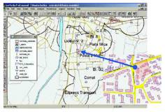
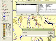
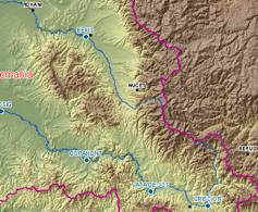
ANNEX 1
Aspects
and Specialized reports
|
|
This picture
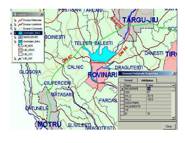
show the situation of geographical distribution of the overtaking of the
critical limits for Jiu and Gilort rivers, information requested by the
Civil Protection Flood Sub commission |
|
|
Graphical
example showing the road sectors DN 67 Tg. Jiu – Motru with
breakings; information requested by the Civil Protection Roads Sub
commission |
|
|
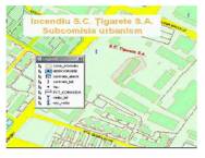
The map for Urban
Sub commission in a fire application for Cigarettes factory Tg. Jiu. The
groups, battalions, companies, fireman platoons, the affected areas,
affected buildings and the rescues medical interventions and the
shelting of affected persons are represented |
|
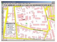
|
The
graphical representation for electrical Networks Sub commissions in a
damage application at the North Station in Tg. Jiu. |
|
|
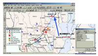
Map for
Medical Sub commission representing the case of epidemic hepatitis A in
Tg. Jiu. |
|
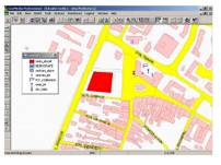
|
Simulation of
an attack at the Prefecture, map requested by the Guard and Order Sub
commission. |
|
|
This map show an exercise for
simulating sabotage at the Central Point of Telecommunications requested
by the Telecommunications Sub commissions for detailed
information needed by intervention’s plan management. |
|
|
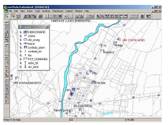
Locality associated fields in a database of the water directorate Crisuri |
|
|
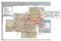
The evolution of hydrological level
updated in real time by prototype from county Bihor. |
0